Hot Air Balloons
&
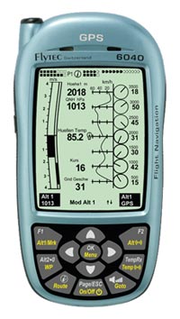
The Flytec 6040 Instruments
© 2009 Keith Sproul

Flytec 6040 Balloon Instruments Web Page
|
GOAL: The primary goal of this website is to provide Controled Airspace files for downloading into the Flytec 6040 Variometer. Once donwloaded into the Flytec 6040, These files make it so that it will warn you when you are getting close to controlled airspace. They should also work in the Flytec 6030, 6020, 6015. (These have not been tested yet.) If there is an area that you need that is not listed here, send me an email to ksproul@skychariot.com and I will try to do it for you. If you have airspace files or other information about the Flytec 6040, please send them to me and I will put them up here to. COPYRIGHT: This webpage is © 2009 Keith Sproul. The data here can be freely distributed and put on other electronic distribution methods, but please include a link or reference back to this website. DISCLAIMER: This web page contains information about the Flytec 6040 Variomenter and its use with Hot Air Balloons. The information is provided as is, with no gurantees of accuracy. Use at your own risk. This information is not to be used as your primary navigation information. DISCUSSION: For the most part, these files have been modified from the OpenAir Format file at http://soaringweb.org/Airspace/NA/HomePage.html In most cases, the restricted airspace has been greatly simplified, usually into just a circle of the appropriate diameter around the airport. This increases the speed at which the 6040 can calculate the air spaces. The following is from the 6040 manual:
Creating airspace files takes knowledge of airspace charts, lat/lon, and understanding how the Flytec 6040 uses them. The "Airspace" feature is also very useful for PZs or Prohibited Zones, also called Red Zones. The best thing to do is to use the CIRCLE feature and simply create a circle around the airport. To do this, you need to do NEW -> RESTRICTED AREA, then once you have created that, do NEW -> CIRCLE. The circle has three parameters. Latitude, Longitude, and diameter. Look up the lat/lon of your airport, enter these numbers, then figure out the diameter of the circle you need. Most class B Airports are 20 miles. A good place to look airport lat/lon is at http://www.airnav.com/airports/ HOW TO USE THIS INFORMATION: There are steps required that are not as obvious as they could be. After you have installed the FlyChart Software do the following:
|
Data Files
(Right-Click and do SAVE AS)| Airport Code | Airport Name | Data File |
|---|---|---|
 Arizona | ||
| PHX | Phoenix | PHX.fa5 |
 Kentucky |
||
| SDF | Louisville - Standiford Field & Bowman Field | SDF.fa5 |
 Missouri |
||
| STL | St Louis | STL.fa5 |
 New Jersey |
||
| EWR | Newark Liberty | EWR.fa5 |
 New Mexico |
||
| ABQ | Albuquerque | ABE.fa5 |
 New York |
||
| NYC | New York City Aera Airports | NYC.fa5 |
 Pennsylvania |
||
| ABE | Allentown-Bethleham | ABE.fa5 |
| HBG | Harrisburg Lancaster Ft Indiantown |
HBGL.fa5 |
| PHL | Philadelphia | PHL.fa5 |
| PIT | Pittsburgh Beaver Falls Latrobe Wheeling Yougstown/Warren |
PIT.fa5 |
 Ohio | ||
| DAY | Dayton Wright Pat Airforce Base Springfield |
DAY.fa5 |
 Texas | ||
| AMA | Amarillo | AMA.fa5 |
| DFW | Dallas, Ft Worth | DFW.fa5 |