Last updated 7/5/2026 16:41:40
Jump to Bottom
DigitTool
| ||||||||||||||||||||||||||||||||||||||||||||||||||||||||||||||||||||||||||||||||||||||||||||||||||||||||
 | ||||||||||||||||||||||||||||||||||||||||||||||||||||||||||||||||||||||||||||||||||||||||||||||||||||||||
Display
| ||||||||||||||||||||||||||||||||||||||||||||||||||||||||||||||||||||||||||||||||||||||||||||||||||||||||
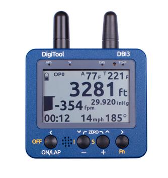
The DigitTool is an FAA approved temperature monitor for hot air balloons. It is a replacement for your Ball instruments, or FlyTec instruments. The DigiTool temperature sensor mounts on the same kind of mount that the FlyTec used, so if your balloon is FlyTec ready, it is also DigiTool Ready. The DigitTool unit has all the same readings as the FlyTec, Ambient Temperature, Envelope Temperature, Altitude, Vertical Speed. In addition to these, it also has a GPS, and it shows you speed and heading. The really cool feature is that the temperature data can be downloaded. See below for some Google Earth screen shots with temperature displayed on the flight tracks. | ||||||||||||||||||||||||||||||||||||||||||||||||||||||||||||||||||||||||||||||||||||||||||||||||||||||||
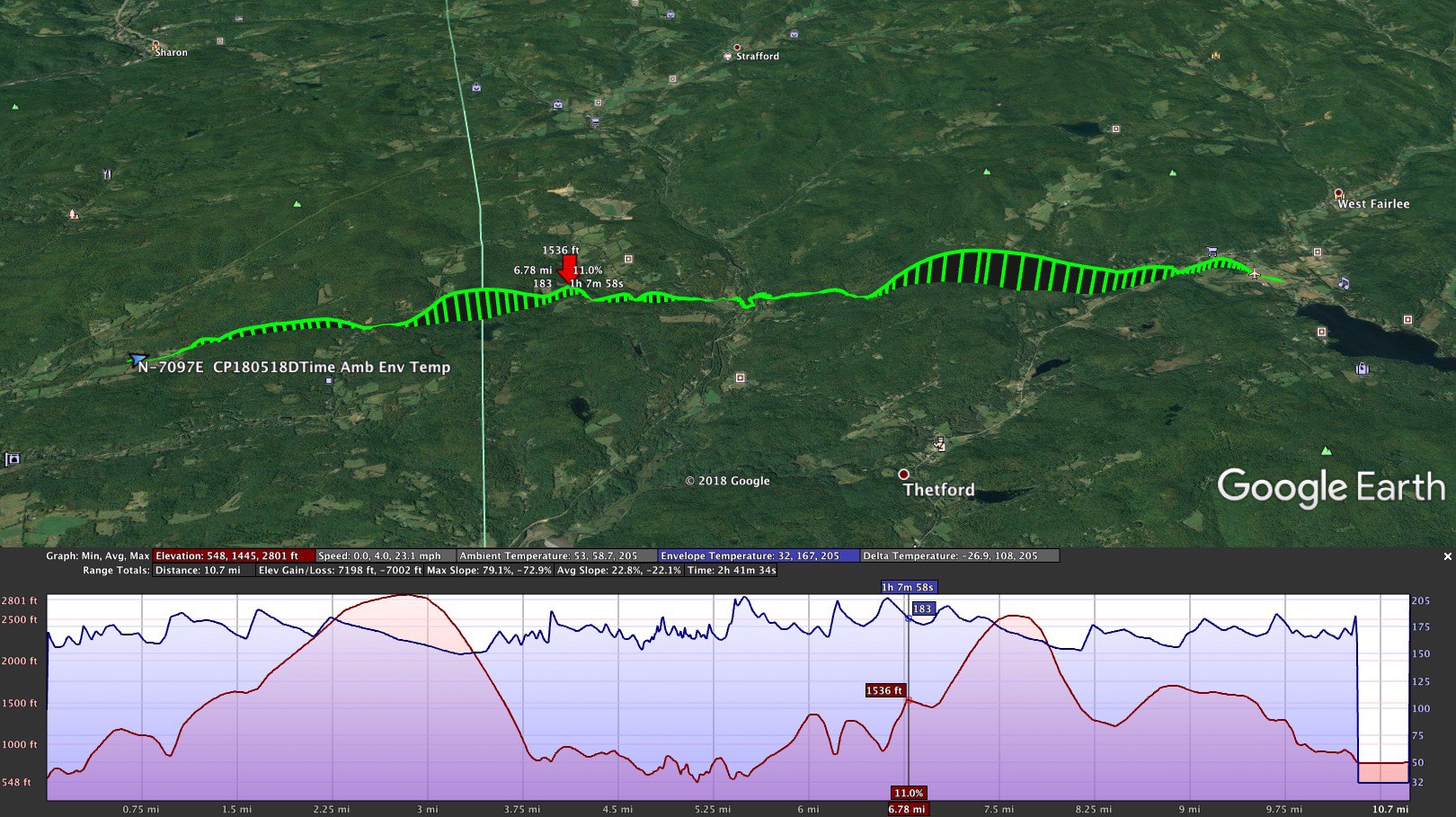 May 18, 2018 AM Post Mills, VT EBAA - Experimental Balloon & Airship Association | ||||||||||||||||||||||||||||||||||||||||||||||||||||||||||||||||||||||||||||||||||||||||||||||||||||||||
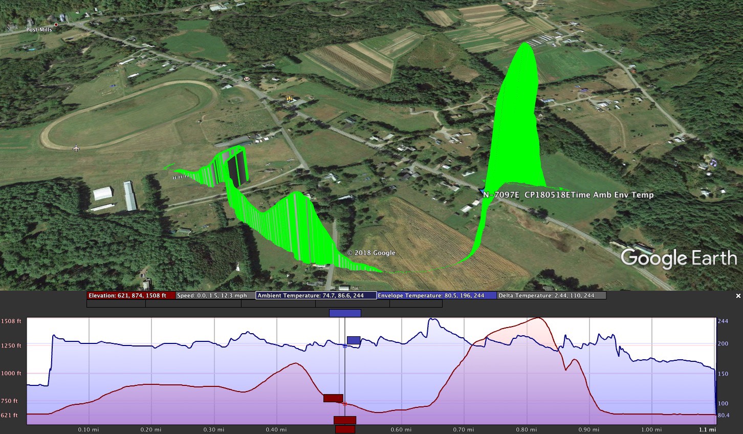 May 18, 2018 PM Post Mills, VT EBAA - Experimental Balloon & Airship Association | ||||||||||||||||||||||||||||||||||||||||||||||||||||||||||||||||||||||||||||||||||||||||||||||||||||||||
| ||||||||||||||||||||||||||||||||||||||||||||||||||||||||||||||||||||||||||||||||||||||||||||||||||||||||
Icons showing temp Color represents temperature | ||||||||||||||||||||||||||||||||||||||||||||||||||||||||||||||||||||||||||||||||||||||||||||||||||||||||
DBI Log File Format
| ||||||||||||||||||||||||||||||||||||||||||||||||||||||||||||||||||||||||||||||||||||||||||||||||||||||||
"For once you have tasted flight you will walk the earth with your eyes turned skywards,
for there you have been and there you will long to return."
- Leonardo da Vinci
"It is possible to fly without motors, but not without knowledge and skill."
- Wilbur Wright
"Ballooning is a philosophy of life. You're a prisoner of the wind. You can swear, shout, pray, cry - and it doesn't matter.
But if you change your altitude, you can go a different direction"
- Bertrand Piccard
"Life is not measured by the number of breaths we take, but by the number of moments that take our breath away."
- Will Smith
"A jack of all trades is a master of none,
but oftentimes better than a master of one."
-William Shakespeare
"Time is the most valuable gift you can give someone"
- Unknown
WWW.SKYCHARIOT.COM Home & Schedule
Keith Sproul's Festival History
Scorch the Dragon Hot Air Balloon
Pandy Hot Air Balloon
Tetrahedron Hot Air Balloon
Birthday Cake Hot Air Balloon
Pig Headed Hot Air Balloon
Fred B Rabbit Hot Air Balloon
Meteor Crater Flight
Letchworth State Park, NY Gorge Flights
Shooting the Delaware Water Gap PA/NJ
Palo Duro Canyon State Park, Amarillo, TX
Red Rock Balloon Festival, Gallup, NM
2007 Switzerland Balloon Festival
Dawn Patrol Flights
Splash-N-Dash Flights
Fried Photogrpaher Pictures
Chariot Balloons
Keith's Cameron Duo Chaiot
Balloon Flights in 3D
Keith's Balloons on Tattoos
Aerostar Aurora Balloons
Aerostar S40A (31K) Balloons
Aerostar S50A (40K) Balloons
Aerostar S55A (77K) Balloons
Aerostar S57A (90K) Balloons
Aerostar S60A (105K) Balloons
Aerostar S66A (141K) Balloons
Aerostar S71A (180K) Balloons
Aerostar S77A (211K) Balloons
Aerostar S81A (245K) Balloons
Aerostar RX6 (56K) Balloons
Aerostar RX7 (77K) Balloons
Aerostar RX8 (90K) Balloons
Aerostar RXS8 (105K) Balloons
Aerostar RX9 (126K) Balloons
Balloon Parachute Artwork
Balloon Pictures from the Bottom
Red, White & Blue Balloons
Arrow Design Balloons
Flame Design Balloons
Parachute Drop Pictures
List of University Balloons
FLIR Balloons Pictures (Infrared heat picture)
Flytec Instruments Info Page
Digitool Instruments Info Page
How to make a Hot Air Balloon
How to make a Tetrahedron Hot Air Balloon
How to put turning vents into a Hot Air Balloon
Envelope / Basket Retrieval Cart
Hot Air Balloon Crew Training
Twins
Bonnie, our Dog
Critters at our front door
Mark Sproul's Observatory
Mark & Keith's GAIA Star Database Project
Keith Sproul's N-Scale Trains
aviationweather.gov
www.ventusky.com
www.windy.com
usairnet.com Winds Aloft
www.blastvalve.com
1-800-WX-Brief